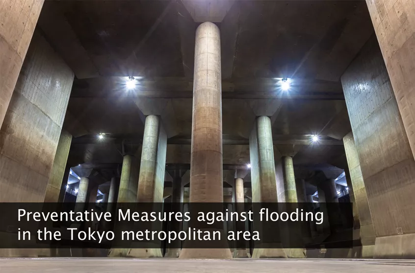
Preventative Measures against flooding in the Tokyo metropolitan area
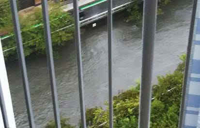
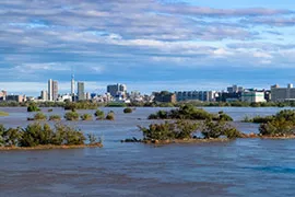
This year’s strongest typhoon–No. 19 (Hagibis)–has brought record breaking heavy rains throughout eastern Japan. It has caused the flooding of some major and numerous small rivers in various areas which caused significant damages to the nearby housing and infrastructure. Because of damage caused by the recent floods, measures taken against the flooding of rivers flowing through the Tokyo metropolitan area are garnering attention. With a quick look over Central Tokyo’s highly developed cityscape you will notice a lack of space for an anti-flood pond. However, there are in fact various measures in place to divert flood water underground or to the upstream areas of major and small rivers in order to prevent Central Tokyo and the metropolitan area from flooding. It is observed this time that these functions have shown the visible results to minimize the flood damages in the Tokyo metropolitan area.
Here is an overview of the preventative measures taken in the Tokyo metropolitan area against flooding.
Metropolitan area’s outer underground discharge channel
Metropolitan area’s outer underground discharge channel is one of the world’s largest underground water diversion facilities–located in Kasukabe, Saitama–and is known as “underground temple” due to its unique structure. The facility connects 5 major waterways and rivers such as the Nakagawa, Kuramatsu, and Ootoshi-Furutone Rivers, and drains the water from them directly into the Edogawa River to prevent the city and its surrounding areas from flood damage. The 6.3km long facility consists of 5 silo-shaped water storage spaces–of varying sizes–each connected by tunnels that were constructed approx. 50m underground.
The Edogawa River Office of the Kanto Regional Development Bureau of the Ministry of Land, Infrastructure, Transport and Tourism, says that during typhoon No. 19 (Hagibis), the facility was near full capacity nearly reaching the limit of its functional capabilities. When typhoon No.19 came through the area, the water level in all 5 waterways and rivers rose while the underground channel soon began operating near its full capacity.

The facility holds 670,000m3 (cubic meters) of water at once, which is approximately a volume equivalent to Sunshine 60 (the landmark 60 story building in Ikebukuro, Tokyo). Since the start of its operation (2006), while in operation about 7 times per a year on average, the most water drained from the channel at once was a total of 19,000,000m3 (2015). After typhoon No. 19, from the 12th of October until the morning of the 14th of October (about 2 days), the channel drained 10,000,000m3 of water, which is equivalent to 15 Sunshine 60’s.
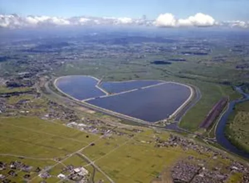
Arakawa first detention basin (Lake Saiko)
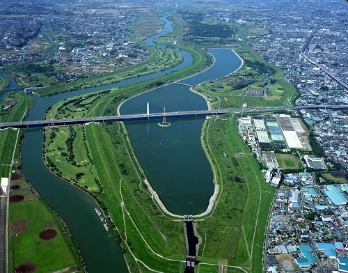
Image from Arakawajoryukasenjimusho 荒川上流河川事務所より
The Arakawa River has also various measures in place to prevent a huge flood. One of them is the Arakawa First Detention Basin (also called Lake Saiko) located in Saitama Pref. This facility has the ability to drain water from the Arakawa River when its water level rises beyond a maximum acceptable level. The basin has had to perform this function only once since the completion of Lake Saiko in 1997 (Completion of the whole detention basin: 2003). Typhoon No. 19 marks the 2nd time since its completion that Lake Saiko has had to mitigate that amount of water in the Arakawa River. The plan was for Lake Saiko to detain 39,000,000m3 of river water. The last time it had to be used (1999) it drained only about 30,000m3 from the Arakawa River. This time the detention basin almost filled Lake Saiko, showing just how much heavy rain Typhoon No. 19 (Hagibis) brought into eastern Japan and how much the risk of the Arakawa River flooding has been mitigated.
Loop Road No.7 Underground Regulating Reservoir
This huge facility was constructed beneath the area of Kannana-Dori Ave and includes a 4.5km long underground tunnel with a 12.5m inner diameter. Stage 1 of the reservoir’s construction was completed in 2008, taking a total of 10 years. Stage 2 of the construction was supposed to be 10 years as well, but the expansion of the reservoir’s capacity is still in progress. The reservoir can store approximately 540,000m3 of floodwater taken from three intake facilities located on the Kanda River, Zenpukuji River, and Myoshoji River.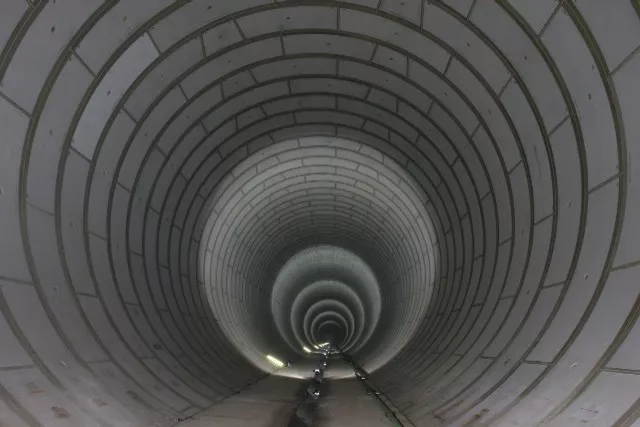
Loop Road No.7 Underground Regulating Reservoir
Image from Tokyo Sogo Chisuitaisaku Kyogikai 東京都総合治水対策協議会より
Underground Regulating Reservoirs of Meguro River
Meguro River
Ebara Chosetsuchi Image from Tokyo Sogo Chisuitaisaku Kyogikai 東京都総合治水対策協議会より
There are two regulating reservoirs for the Meguro River, which are the Ebara Regulating Reservoir (Completion in 2001 / capacity 200,000m3) and the Funairi Regulation Reservoir (completion in 1990 / capacity 55,000m3). The two facilities consist of underground reservoir spaces with the multiple floor configurations and a water intake window on the inside upper levee wall. The reservoirs drain water from the Meguro River before it can overflow when the water level becomes extremely high. Combined, the two reservoirs can hold 255,000m3 to prevent the area along the Meguro River from flood water damage such as the area’s residents have struggled with for a long time.
Other preventative Measures for flooding in the Tokyo metropolitan area
The Detention Basin Funtion of the area around International Stadium Yokohama (Nissan Stadium)
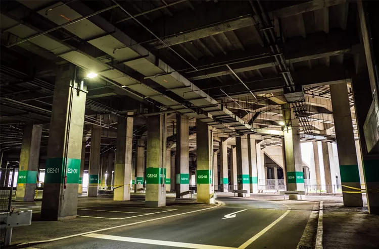
Nissan Stadium Parking
The detention basin function of Shin-yokohama Park which houses the International Stadium Yokohama (Nissan Stadium)–host to the 2019 Rugby World Cup held in Japan–attracted the attention of various television news programs soon after the passing of Typhoon No. 19 (Hagibis). In the aftermath of Typhoon No. 19 (Hagibis), television news programs broadcasted the surprising scene of water drained from the Tsurumi River filling up Shin-yokohama Park making Nissan Stadium appear as if it was built on an island.

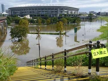
While Shin-yokohama Park normally acts as the largest sports park in Yokohama–with its various sports fields–the park also functions as a detention basin with a water intake gate facility on the Tsurumi River. Shin-yokohama Park was built in an area that historically suffered from occasional flooding. Keeping the area's history in mind the park was constructed with the dual purpose function of being a sports park during good weather and a detention basin in the event of a flood. So as not to hinder the parks detention basin function, Nissan Stadium was constructed on pillars above ground so that water can also be held under the stadium. The detention basin facility aspect is managed and operated by the Keihin River office section of the Ministry of Land, Infrastructure, Transport, and Tourism.
The 4 Retarding Basins of the Tone River
Watarase Yusuichi Image from Kazo City 加須市
The Tonegawa upstream river office of the Ministry of Land, Infrastructure, Transport and Tourism reported on Oct 14th that the Watarase, Sugo, Inadoi, and Tanaka Retarding Basins on the Tone River detained about 250,000,000m3 (equivalent to the volume of 200 of Tokyo Domes) in total. This record breaking volume of water is the most water that has been detained at these 4 facilities since their construction.
- Floods in Tokyo and Safety Tips and Preparation
- Japan, located in the eastern end of Monsoon Asia, one of the world's rainy regions, has an average annual rainfall of 1718 mm, which is about twice the global average (880 mm).

- Rental Apartments & Houses in Tokyo
- Listings of popular and luxurious rental apartments, condominiums, and houses
- designed with expats in mind.

- Apartments & Houses for Sale in Tokyo
- Listings of apartments, condominiums, and houses available for purchase in Tokyo.